What Satellite Images Don’t Tell Us - and How Open Sources Help Fill the Gaps
| AUTHOR | Ayoush |
| DATE | August 17, 2026 |
| CATEGORIES | Geospatial Intelligence Defence Satellite Imagery Open Source Intelligence (OSINT) |
Satellite imagery is extremely useful for tracking military activity. It can show where new infrastructure has appeared, how large a site is, and how it develops over time. But there is a limit to what can be understood from overhead imagery alone. A building may clearly be military, for example, without revealing which unit occupies it or exactly what purpose it serves.
This is where other open sources can become particularly valuable.
A useful example can be seen at several locations opposite Ladakh. Satellite imagery shows a recurring type of permanent military construction at geographically separate sites opposite the Depsang Plains, Chang Chenmo, Gogra–Hot Springs and the Depsang Bulge. The individual sites are not identical, but some of their structures and layouts are similar enough to suggest that they may form part of a wider pattern.
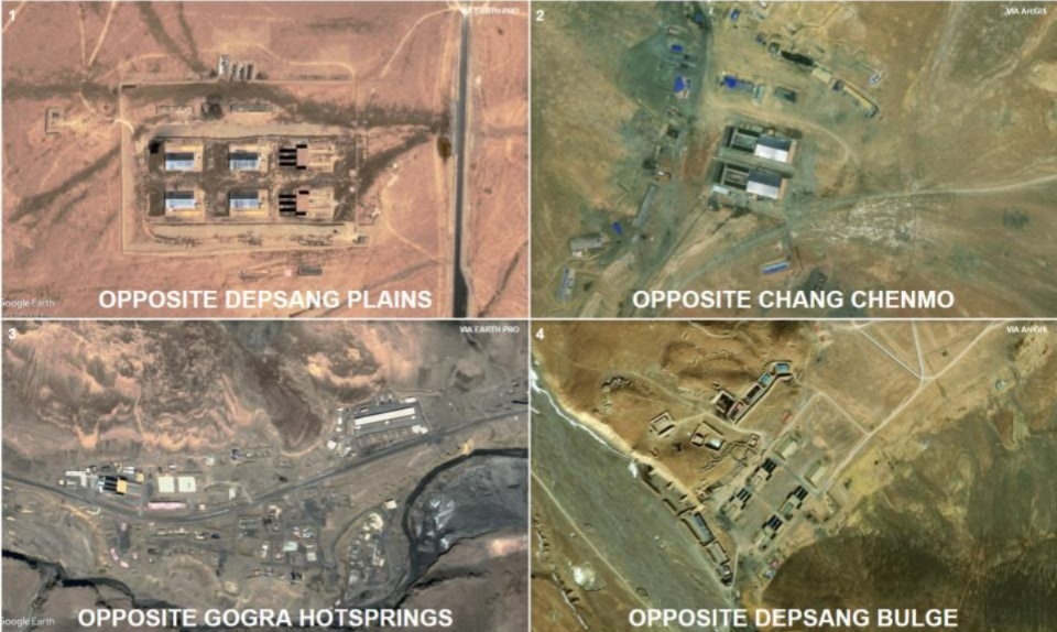
On imagery alone, however, that similarity can only take the assessment so far. Similar buildings may not necessarily mean similar branches of the PLA.
Additional context comes from publicly available Chinese military footage. A CCTV broadcast shows regular People’s Liberation Army Ground Force (PLAGF) troops associated with a Combined Arms regiment operating in the Ladakh region. The PLAGF is the land warfare component of the People’s Liberation Army, responsible for China’s conventional ground combat forces, including its combined-arms formations.
This matters because regular PLAGF formations are distinct from the border-defence forces routinely responsible for manning and patrolling much of the frontier. The footage therefore provides evidence that regular ground-force elements are not simply exercising somewhere on the Tibetan Plateau, but are operating from infrastructure positioned close to the border.
The key step is geolocation.
Features visible in the ground footage—terrain, ridgelines, roads and the arrangement of buildings—can be compared with satellite imagery. Once the location of the footage is established with reasonable confidence, structures visible in the video can be matched against those seen from above. What was previously an unidentified military building on a satellite image now has an additional piece of context: regular PLAGF personnel have been observed using infrastructure of that type at a confirmed location.
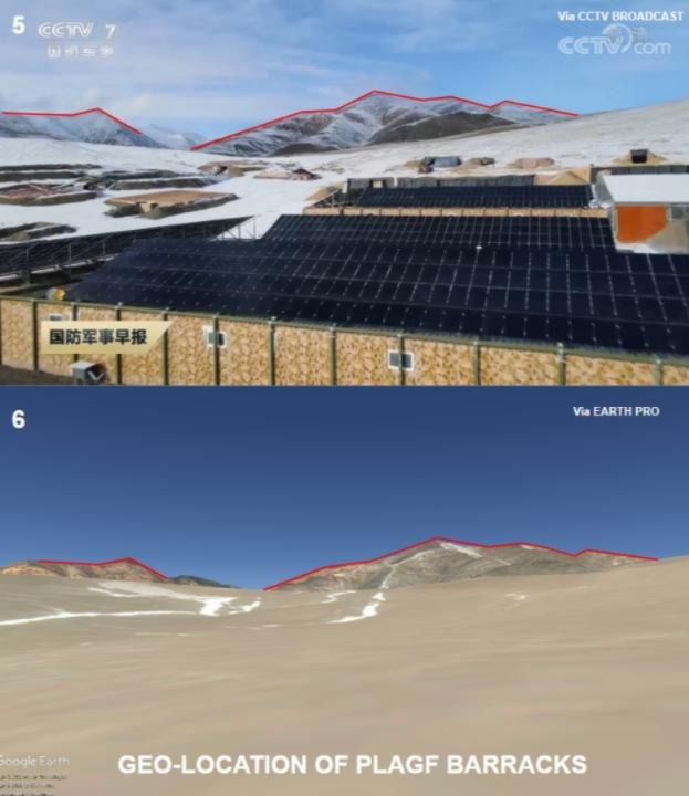
That does not mean every similar building elsewhere can automatically be labelled as belonging to the same regiment, formation or even the same type of unit. PLA infrastructure can be standardised, and similar buildings may serve different purposes. But it does provide a useful reference point.
The significance becomes clearer when the same or closely comparable permanent structures appear repeatedly across separate locations opposite Ladakh. Instead of treating each site as an isolated observation, analysts can begin examining whether they collectively indicate a wider footprint of regular PLAGF mobilisation along the sector.
This is particularly important when trying to distinguish regular-force mobilisation from routine border activity. The existence of a military facility close to the Line of Actual Control does not, by itself, establish the presence of regular manoeuvre formations. Geolocated footage showing regular PLAGF troops at one of these facilities provides a stronger basis for interpreting comparable infrastructure elsewhere, especially when supported by additional indicators.
Satellite imagery can then add another dimension: scale.
If comparable facilities can be identified across multiple locations, their number, distribution and physical footprint provide useful indicators of how extensive the deployment may be. Expansion over time can also show whether an initially temporary presence is becoming more permanent. In some cases, the capacity of camps, vehicle areas and supporting infrastructure may contribute to broader estimates of the forces they are designed to sustain.
These estimates still need to be treated cautiously. A building cannot be converted directly into a personnel figure, and two apparently identical facilities may not have identical occupancy. Structural similarity is therefore better treated as corroborating evidence rather than proof of a particular unit identity or strength.
The real value comes from combining different pieces of evidence.
Satellite imagery establishes the physical footprint. Ground footage can show who is using it. Geolocation connects the footage to a specific site. Temporal imagery can then show when that infrastructure appeared, how it expanded and whether it has remained in use. When the same structural pattern appears elsewhere, those confirmed locations provide reference points for examining the wider deployment.
For PLA activity opposite Ladakh, this approach can help turn a collection of otherwise disconnected military sites into a more coherent picture. It does not require assuming that every similar structure belongs to the same formation. Instead, the assessment can be built incrementally: identify a recurring feature, find an independent reference for it, establish where that reference was recorded, and then examine how widely the same pattern occurs.
That is ultimately where open-source corroboration becomes most useful. It does not replace what can be seen in satellite imagery. It helps explain what the imagery may actually represent.